-
 The planning area spans from Cape Cheerful, across Unalaska Bay and out east to Erskine Point. That includes several smaller bays within Unalaska Bay as well as Kalekta Bay. The Alaska Department of Natural Resource (DNR) proposes classifying the land under three categories: as wildlife habitat, public recreation land and waterfront development land. The waterfront development section would include an area from Mount Ballyhoo, near the airport, south into Captain’s Bay, into Iliuliuk Creek and around Unalaska Lake, according to DNR’s Unalaska Bay Site Specific Plan Public Review Draft.
 -
 Two dead whales have washed up on Unalaska's shores in the past week: an adult fin whale — which is the second largest mammal in the world — and a…
 -
 Alaska state and local health officials are warning of dangerously high levels of toxins in shellfish, after a person died of paralytic shellfish…
 -
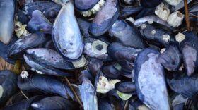
 Blue mussels and snails (whelks) collected from Unalaska Bay on July 4 registered nearly three times the U.S. Food and Drug Administration's Paralytic…
 -
 'Not Drawing Any Conclusions At This Point:' NTSB Releases Preliminary Report On Medevac Plane CrashThe National Transportation Safety Board (NTSB) has released its preliminary report on a medevac airplane that crashed into the waters of Unalaska Bay…
 -
The U.S. Coast Guard has reported a fuel sheen about 50 feet wide and 1,500 feet long in Unalaska Bay where a LifeMed medevac plane went into the water…
-
 Unalaskans helped to free a humpback whale last weekend after it was caught in fishing lines and buoys in Unalaska Bay.A responder with the National…

© 2024 KUCB

Your voice in the Aleutians.
Play Live Radio
Next Up:
0:00
0:00
Available On Air Stations


